Table of Contents >> Show >> Hide
- The Plot Twist: The “Jungle” Was Hiding in Plain Sight
- How Google + LiDAR Turned a Hunch Into a City
- Not a One-Off: The Laser Age of Maya Archaeology
- Discovery vs. Confirmation: Why Archaeologists Still Put on Boots
- What These Discoveries Tell Us About the Ancient Maya
- How to Search Google Like an Archaeologist (Responsibly)
- Conclusion: The New Expedition Gear Is Search, Data, and Patience
- Field Notes: of “Screen-Side” Experiences You’ll Recognize
Indiana Jones had a whip. Modern archaeologists have Wi-Fi. And sometimesno kiddingthe internet connection is the most dangerous part of the expedition. Not because of snakes or quicksand, but because “just one more search result” turns into three hours of tabs, a melted laptop fan, and a shocking realization: the “empty jungle” on the map is only empty because nobody zoomed in far enough.
That’s basically how the lost Maya city now known as Valeriana came back onto the world’s radar: not with machetes, but with a Google search that surfaced a forgotten public dataset. Add some LiDAR (laser mapping), serious archaeological know-how, and the humility to double-check everything on the ground, and you’ve got one of the most “welcome to the future” stories in modern Maya archaeology.
The Plot Twist: The “Jungle” Was Hiding in Plain Sight
The classic story of “lost cities” usually starts with a sweaty trek. This one starts with a researcher doing what all of us do when we’re procrastinatingsearching the internetexcept with a much better reason and fewer cat videos.
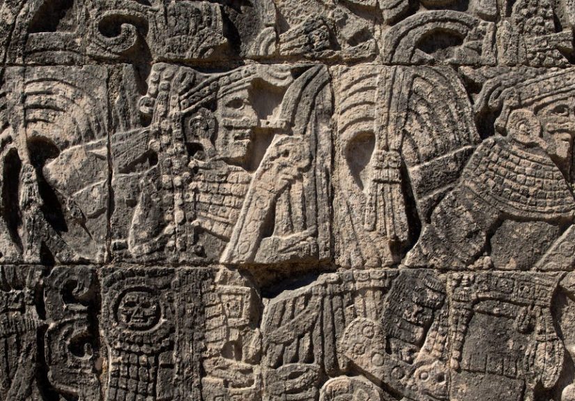
Archaeologist Luke Auld-Thomas and collaborators were investigating settlement patterns in the Maya Lowlands when he stumbled across an environmental LiDAR dataset that had been collected for forest monitoringnot archaeology. The dataset covered part of Campeche, Mexico, a region long known to be archaeologically rich but still full of blank spots in modern surveys. That “blank” turned out to be more like “crowded, engineered, and quietly monumental.”
So What Exactly Was Discovered?
From the LiDAR point cloudthink of it as a hyper-detailed 3D sketch of the landscaperesearchers identified evidence of thousands of ancient structures across the mapped area. Within that landscape sat a major, previously unrecorded urban center that the team named Valeriana, after a nearby lagoon.
In plain English: the scan showed the kind of features archaeologists associate with a big deal Maya political centerpyramidal mounds, enclosed plazas, causeways, reservoirs, and dense residential zones. It wasn’t a lone “mystery pyramid.” It looked like an entire city system with neighborhoods, civic spaces, and infrastructure.
One of the most eyebrow-raising details is how close this was to modern life. Reports emphasized that the ruins are near existing roads and communitiesclose enough to make you wonder how the city stayed “lost” at all. The short answer: dense vegetation, limited systematic survey coverage in that specific patch, and the fact that many Maya structures look like natural hills until you know what you’re looking for.
Why “Found Data” Is a Big Deal in Archaeology
Archaeology has a sampling problem. Traditionally, researchers map places they already suspect will be interesting (understandableyou only have so many grant dollars and bug-spray refills). But that can bias our picture of the past toward famous sites and away from “ordinary” landscapes.
Environmental LiDAR flips that. Because the data was collected for a different purpose (like forest carbon monitoring), it’s less likely to be pre-selected around known ruins. In other words, it can reveal what the region really looks like when you’re not “cherry-picking” the archaeologyhelping answer a surprisingly spicy question: Were ancient Maya landscapes truly packed with settlement and infrastructure, or did we just keep mapping the densest places?
Valeriana strongly supports the idea that dense settlement and “low-density urbanism” (spread-out cities integrated with farmland and water systems) weren’t rare exceptions. They may have been a normal feature of the Maya Lowlandsjust unevenly documented until recently.
How Google + LiDAR Turned a Hunch Into a City
Let’s demystify the tech for a secondbecause “laser mapping” sounds like either a superhero origin story or a suspicious gadget from a late-night infomercial.
LiDAR in One Breath (Without Passing Out)
LiDAR stands for Light Detection and Ranging. An aircraft (or drone) sends out pulses of laser light and measures how long they take to bounce back. Do that millions of times and you get a precise 3D model of the groundeven under forest canopy. Archaeologists often call the processing step “digital deforestation,” because you can strip away trees in the model and see the terrain like the jungle isn’t there.
That’s why LiDAR is such a game-changer in tropical archaeology. Maya cities aren’t gone; they’re just wearing 1,500 years of landscaping.
Google’s Role Wasn’t MagicIt Was Access
The headline-friendly version is “Major lost Maya city discovered while searching Google.” The grown-up version is: open data and searchable archives made it possible for an archaeologist to find a high-quality dataset that hadn’t been analyzed for ancient settlement.
That’s not the same as “Google discovered the city.” Google was the library catalog. The “discovery” happened when trained experts recognized patterns in the data, applied archaeological methods, and connected the results to what’s known about Maya architecture, landscapes, and chronology.
Not a One-Off: The Laser Age of Maya Archaeology
Valeriana is dramatic, but it’s part of a wider trend. Over the last decade, LiDAR has helped rewrite what scholars thought they knew about Maya population, infrastructure, and land use.
Guatemala’s “Wait…There’s How Much?” Moment
In northern Guatemala, large LiDAR initiatives revealed tens of thousands of structures across huge swaths of forestalong with causeways, terraces, defensive works, canals, and reservoirs. The takeaway wasn’t just “there were more buildings.” It was that Maya cities formed regional networks with engineered landscapes and serious investment in agriculture and water control.
Some of the most surprising finds in those scans included defensive walls and fortifications in places where older narratives assumed relatively peaceful city-states until “late collapse chaos.” The lasers suggested conflict and large-scale planning were present more broadly than once thought.
Mexico’s Campeche Keeps Delivering: Ocomtún and Beyond
Campeche, in particular, has been lighting up (politely) under LiDAR. In 2023, researchers working with Mexico’s national heritage authorities announced the discovery of Ocomtún, a monumental Maya site in the Balamkú ecological reserve. LiDAR guided teams toward pyramidal structures, plazas, and civic spacesevidence of another important regional center during the Classic period.
Put Valeriana beside Ocomtún and the message is hard to ignore: there are still major Maya sites left to document, even in regions that are not truly “unknown,” just under-mapped with modern tools.
Preclassic Scale: The Mirador–Calakmul Region
LiDAR has also highlighted how ambitious earlier Maya (and related Mesoamerican) societies were. Surveys in the Mirador–Calakmul area of Guatemala have identified extensive networks of settlements and long causeways tied to Preclassic developmentevidence that large-scale planning and connectivity began earlier than many people assume when they picture “classic” Maya cities.
Discovery vs. Confirmation: Why Archaeologists Still Put on Boots
Here’s where we separate exciting headlines from reliable science.
LiDAR Finds Shapes. Archaeology Finds Answers.
LiDAR is phenomenal at revealing formsplatforms, terraces, mounds, roadbeds, and canals. But it can’t, by itself, tell you who built something, when they built it, or how it was used. That requires “ground truthing”: visiting locations, documenting architecture, collecting diagnostic ceramics, and (when appropriate) excavating to establish dates and functions.
In other words: LiDAR is the world’s best “Where should we look?” machine. It is not a time machine.
Why Some “Google Earth Discoveries” Don’t Hold Up
If you’ve been online long enough, you’ve seen the occasional claim that a person “found a lost city” by spotting a suspicious rectangle on satellite imagery. Sometimes that leads to real discoveries. Sometimes it leads to a painfully confident thread about “ancient aliens” and a rock formation that is, tragically, just a rock formation living its best life.
A famous example involved a teenager who proposed a star-map pattern to locate a missing Maya city and used satellite imagery to suggest structures. Experts pushed back, noting that modern mapping assumptions don’t neatly translate to ancient Maya spatial thinking and that imagery anomalies aren’t proof of architecture. The broader lesson isn’t “citizens can’t help.” The lesson is: remote clues need archaeological verification.
What These Discoveries Tell Us About the Ancient Maya
All the tech in the world is only as interesting as the history it reveals. The Valeriana story matters because it helps answer bigger questions about how the Maya lived.
1) Maya “Cities” Were Often City-Regions
When many people imagine an ancient city, they picture a dense downtown and then countryside. Maya urbanism often looks different: dispersed neighborhoods, agricultural features, causeways, and water systems spread across a broad landscape. The “city” can be a whole region knitted together by movement corridors and shared infrastructure.
2) The Landscape Was Engineered
LiDAR repeatedly reveals terraces, drained wetlands, canals, field boundaries, and reservoirsevidence of careful land management. That matters because it complicates the old cliché that tropical civilizations were inevitably doomed by “primitive” farming. The picture is more sophisticated: the Maya modified ecosystems, managed water, and built systems that could be productiveuntil political instability, drought, warfare, and other pressures made the whole machine harder to run.
3) Collapse Was Not a Single On/Off Switch
Popular narratives love a dramatic collapse. Real history is messier. Evidence synthesized from climate records, inscriptions, and settlement archaeology suggests a mix of prolonged droughts, shifting power, conflict, and migration in different regions at different times. Some centers declined while others adapted. Some areas depopulated; others reorganized. The end of Classic Maya political systems wasn’t the end of Maya peoplemodern Maya communities persist today.
How to Search Google Like an Archaeologist (Responsibly)
If Valeriana makes you want to open a new tab and hunt for pyramids, you’re not alone. Here’s how to do it without becoming the internet’s loudest source of confusion.
Step 1: Look for Open Data, Not Just Pretty Maps
Search for terms like “LiDAR dataset,” “DEM,” “point cloud,” “archaeology remote sensing,” plus a region name. Environmental and government datasets are sometimes publicly available. The key is documentation: you want metadata, collection dates, resolution notes, and licensing clarity.
Step 2: Learn the Visual Vocabulary
Maya features have patterns: rectangular platforms, plaza groupings, causeways (often straight, slightly raised lines), and terracing that follows slopes. But nature makes convincing imposters. Train your eye by comparing confirmed sites with terrain models.
Step 3: Use a Skeptic’s Checklist
- Is there independent evidence? (prior surveys, historical records, local knowledge)
- Do multiple features form a coherent pattern? One mound is interesting; a network is persuasive.
- Could it be modern? Logging roads and agricultural berms can mimic ancient lines.
- Is the claim falsifiable? “It’s a city, trust me” is not a method.
Step 4: Don’t Drop Coordinates Like Confetti
Publicizing exact locations can increase looting risk. If you truly believe you’ve identified something significant, the responsible move is to share information with qualified researchers or heritage authoritiesnot to start a treasure-hunting countdown on social media.
Conclusion: The New Expedition Gear Is Search, Data, and Patience
The best part of the “lost Maya city found while searching Google” story is not that archaeology has become lazy. It’s that archaeology has become broader. Open datasets, remote sensing, and better computational tools are letting researchers see the Maya world at scales that were previously impossibleentire regions, not just famous temples.
Valeriana is a reminder that the past isn’t finished surprising us. Sometimes it’s hidden under vines. Sometimes it’s hidden under the assumption that someone else already checked that dataset. And sometimes it’s hiding on page 16 of your search results, waiting for the one person stubborn enough to keep scrolling.
Field Notes: of “Screen-Side” Experiences You’ll Recognize
If you’ve never tried exploring ancient landscapes from a laptop, the emotional arc is oddly universalwhether you’re a student, a GIS hobbyist, or a professional archaeologist. It starts with optimism (“How hard can it be? The lasers did the work!”) and ends with respect (“Oh. The lasers did some work.”).
First comes the tab explosion. You begin with a simple searchmaybe “Campeche LiDAR download” or “forest monitoring elevation data.” Ten minutes later you’re knee-deep in acronyms (DEM, DTM, LAS, LAZ), clicking through portals that look like they were designed in 2007 and heroically never updated. You learn quickly that the real jungle is not the rainforestit’s the file formats.
Then comes the “Is that…?” moment. Once you finally open a hillshade or a bare-earth model, you start seeing shapes everywhere. Straight lines. Rectangles. Subtle terraces stepping down a slope. Your brain lights up like a pinball machine because humans are pattern-recognition engines. It’s thrilling… and also dangerous, because nature plus modern land use can draw a very convincing fake pyramid. The most responsible feeling you can cultivate at this stage is: curiosity with brakes.
Next comes the humility of scale. A single platform might be a house moundor a modern pile of spoilor a naturally eroded feature. But when you see dozens or hundreds of similarly oriented platforms clustered around plaza-like spaces, connected by linear features that behave like causeways, the interpretation begins to tighten. You stop thinking in “objects” and start thinking in “systems.” That’s when the work feels less like treasure hunting and more like science.
After that, you meet the ghosts of modern activity. Logging roads, firebreaks, berms, canals, and agricultural grids can mimic ancient engineering. Sometimes a perfect straight line is not a sacred processional route; it’s a relatively recent access track. The practical experience here is learning to cross-check: historical imagery, maps, and any published research you can find. The more layers you compare, the less likely you are to fall in love with your first impression.
Finally, you discover the strangest truth: the “Google discovery” is rarely the end of the story. It’s the beginning of a slower, more collaborative phasesharing results, asking for critique, refining methods, and eventually getting someone on the ground to verify. The romance of the lone discoverer fades, replaced by something better: a network of expertise that turns pixels into knowledge without turning heritage into a scavenger hunt.
So yesValeriana-style discoveries can start with a search bar. But the lasting “experience” is learning that the internet doesn’t replace archaeology. It expands it. The most exciting part isn’t that anyone can look; it’s that, with care and rigor, more people can help us understand what we’re seeing.